Greenland Compared To South America
World maps have a tendency to be deceiving. They make some continents or islands look small, and others look gigantic by comparison.
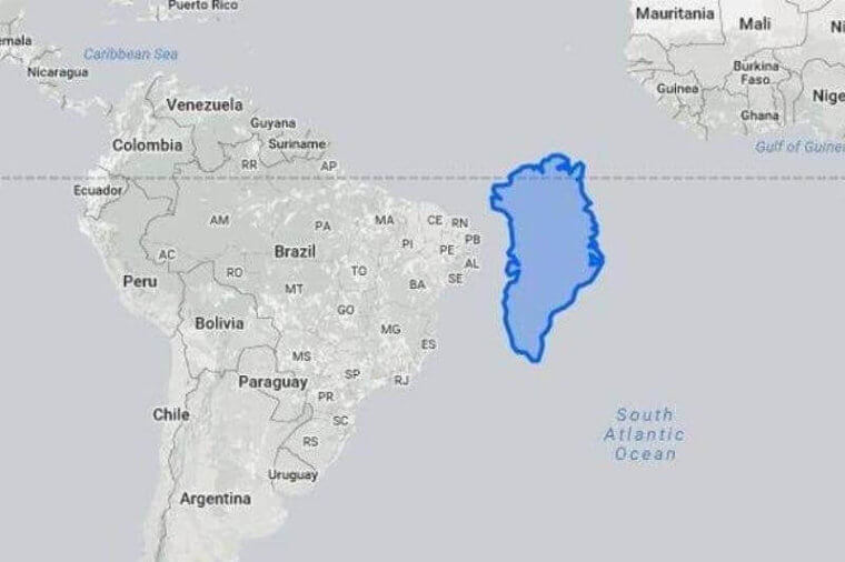
Greenland, when placed in the Northern Hemisphere, always looks massive. Yet, when placed side by side with South America, it is clear that South America could completely swallow the island. It is a whopping 8.2 times bigger.
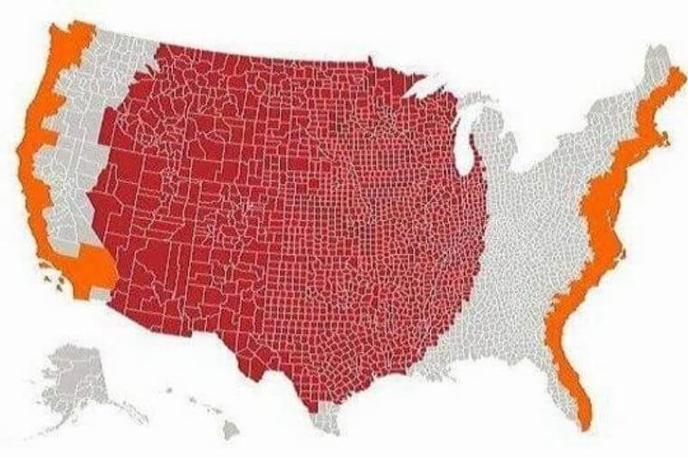
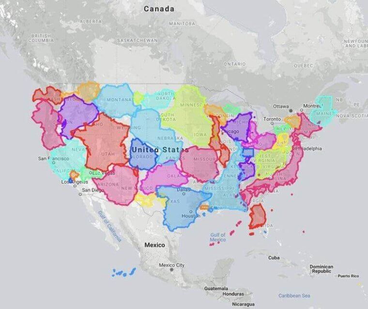
The Actual Population Dispersion Of The United States
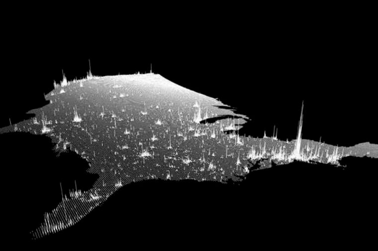
The United States has a population size of just over 300 million. You would think that Americans would be evenly dispersed throughout the States, but this is not the case.
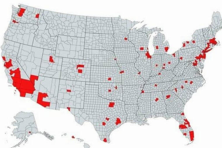
If you look at the ‘red’ spots on the map, you will notice that most of the population is concentrated on the West and East coasts. The interior is not a hot spot for people to move to. The Midwest is excellent for farming, and if you’re interested in leading a quiet life raising livestock and growing crops then that appears to be the place to be.
Texas Vs. Africa
As the saying goes, “Everything is bigger in Texas,” and that is true for things like trucks, belt buckles, and steak. When it comes to the actual area of Texas when compared to the continent of Africa, there is a clear winner.
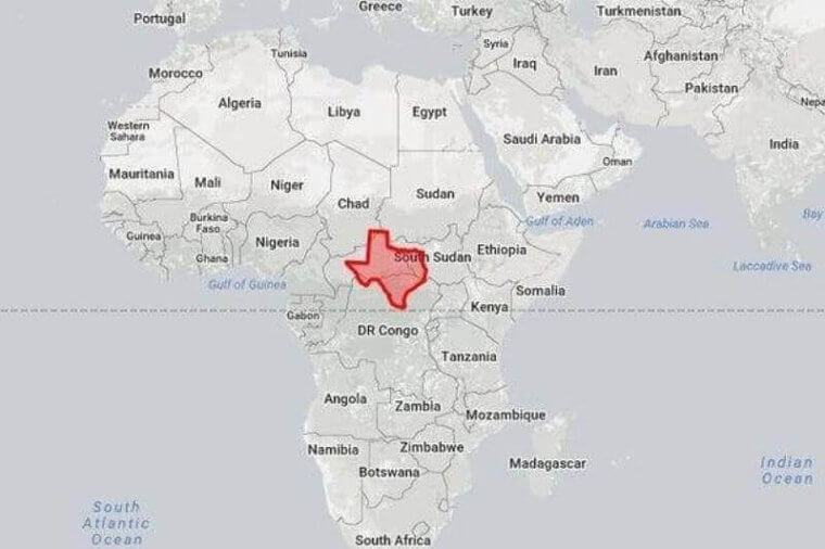
Texas is the size of an African country, but it cannot compete with the entire continent. The continent itself engulfs Texas, as it is 45 times bigger. The continent of Africa is not shown to scale on most maps, which is why a misconception that it is so small exists.
Stargazing
Staring up at the Milky Way and watching the stars dance across the sky is a fabulous nighttime activity. Large cities like New York City and Los Angeles make it difficult to see the stars.
For the stargazing lovers, the States with the least amount of light pollution are the ones in the middle of the country. Head to North Dakota or Wyoming and enjoy the night sky. If you’re on the coasts, you may have trouble seeing the stars twinkle.
Welcome To Middle America
To understand this map, you need to know what the orange and the red sections mean. Essentially, the population size in red is equal to the population size in orange. That means almost the same amount of people live on the coasts, as almost all of middle America.
If you’re looking to buy some land and start a homestead, then head to the Midwest.
Air Traffic Control
Hundreds of airports dot the continental United States, and instead of being in their own individual zones, they belong to this unique set of borders. Instead of being named after the states, they surround, they are named after the major city that they service.
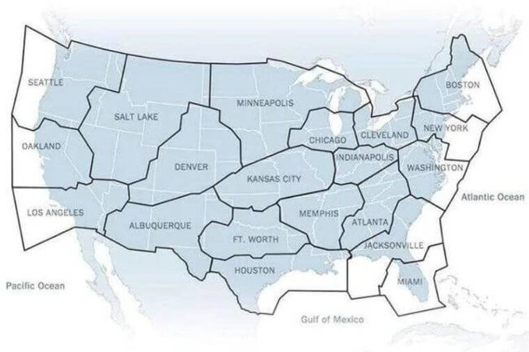
There are 21 zones in total and within those, each airport is responsible for the airspace above it. That airspace has a radius of about five miles.
Understanding Land Use
The United States is fortunate to have a wide variety of ecosystems and biomes that allow for different sorts of industries and land uses. Each part of the country has a designated area for sectors like agriculture, defense, and forestry, and the list goes on and on.
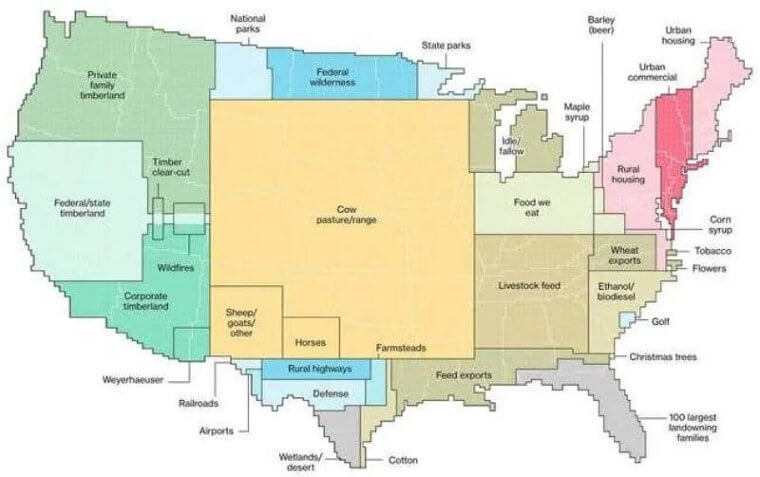
If you examine this map closely, you will see exactly where flowers for florists come from and where biodiesel is allowed to be produced. Most of the country is dedicated to farming in the center, with heavier industry along the coasts.
The Mongolian Empire
Throughout history, empires have risen and fallen. In 1279, the Mongolian Empire was the biggest empire by immediate landmass that the world had ever seen, and it retains this title to this day.
While empires like the Roman and the Greek were also large, they were dispersed and not a cohesive landmass like the Mongolian one. Genghis Khan was the mastermind behind much of this empire.
The Island Nation Of New Zealand
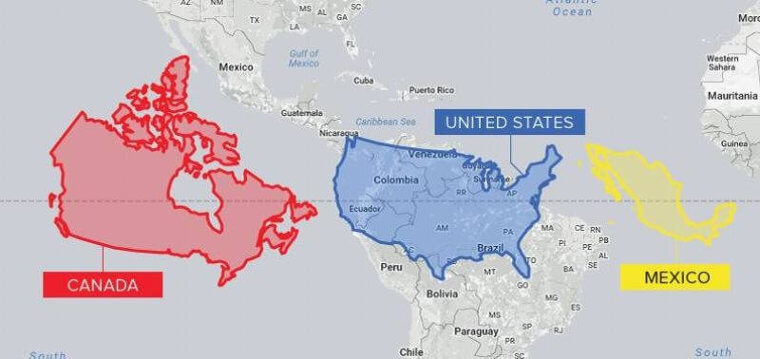
By now, we know that the United States of America is a massive country that dwarfs smaller nations. New Zealand, found in Oceania, has been superimposed over America to once more prove how big it is.
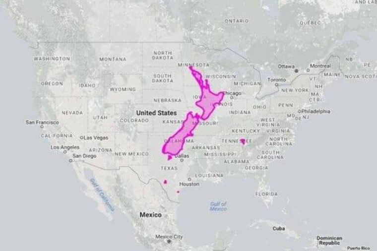
New Zealand, the country responsible for the magnificent landscapes in The Lord of the Rings sits comfortably inside the borders of America. In fact, it is 3,558 percent smaller, which puts it around the same size as the United Kingdom.
Where The Imperial System Is Used
There are two systems of measurement used around the globe: the imperial system and the metric system. Most countries, with a few minor exceptions and one very big one, utilize the metric system of meters, liters, and grams.
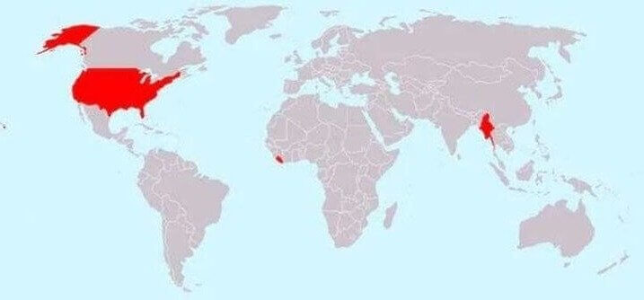
The United States uses the imperial system which involves miles, yards, and gallons. What’s interesting, is that the British are responsible for the introduction of the imperial system, and it continues to be a holdover from the colonial period. Liberia, in West Africa, and Myanmar, in Southeast Asia are the only other countries that use it.
Here’s Where American Forests Are
Forestry is a huge industry, and in order to make it sustainable, trees cut down need to be replaced. The United States is home to almost one-tenth of the globe’s forests, which makes it a major contributor of timber on the world market.
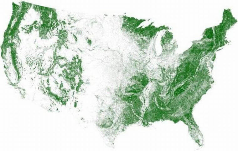
Forestry is a booming industry, and while heavy logging does contribute to the decline of forests, tree-planting programs have actually helped abate this. City mayors and local councilors consistently institute tree planting programs, which is keeping America green.
Railroad To Nowhere
Catching the train, and watching the landscape pass by, is one of the most relaxing modes of transportation out there. During the Industrial Revolution in America, companies began to build railroads in the belief that every city and town would be connected.
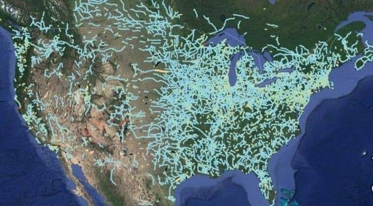
By 1893, this dream came to an end. It was known as ‘the Panic’, and it was a time of economic turmoil which saw many businesses and families go bankrupt. Due to that, there are railroads to nowhere all over the United States.
The Great Flamingo Migration
Bright pink flamingoes can be found in the wild, but only in very specific coastal regions in the world. Flamingoes don’t enjoy cold climates, which means their migratory patterns bring them to the sunny shores of the Southern Hemisphere.
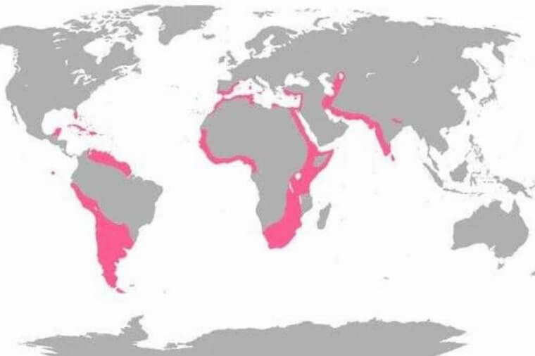
The pink on this map shows that flamingoes enjoy hanging out in South America, Africa, and parts of Asia. Next time you see a flamingo perched on one leg, think about how far they have flown to get there.
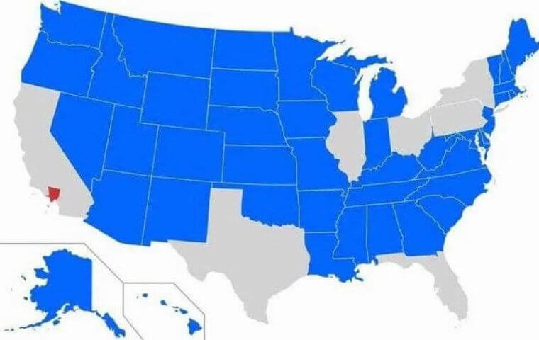
The State Of California
California, known for its size, the plethora of celebs, and sunny beaches could be a country itself based on its size. The state itself has a population of over 39 million, which is more than the population of all of Canada.
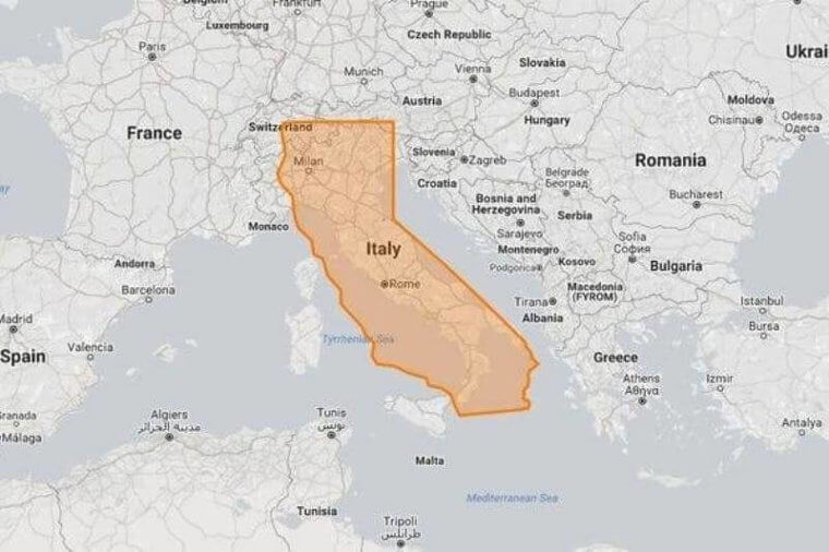
To put this into even more perspective, California is bigger than Italy by about 25 percent. Italy does win in population size though, as it has more than 60 million citizens living within its borders.
Highways To Everywhere
While railroads might have faded into the past in the United States, highways have not. The United States’ Federal Highway Administration (FHWA) is the administrative body responsible for expanding the already impressive amount of miles of highway in existence.
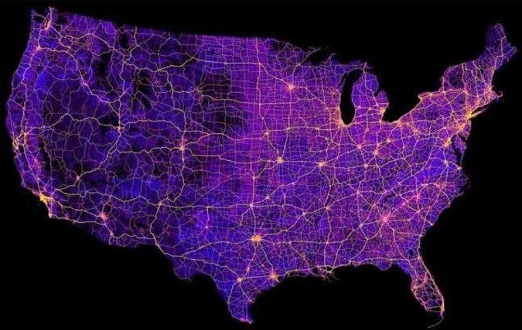
To date, there are 157,724 miles of highway running throughout the continental United States. These highways connect each state, town, and county to one another and require a lot of maintenance. Oddly enough, maintenance is not done on the federal level and is instead left to state authorities. That’s why some highways are better maintained than others.
Dana Evans & Kahleah Copper
Australia And The United States Showdown
Australia is both an island and a continent, which puts it in a very special position. This island nation, found in the Pacific Ocean, is home to the largest coral reef in the world, and some of the most poisonous plants and spiders on the planet. In terms of size, it gives the United States a run for its money.
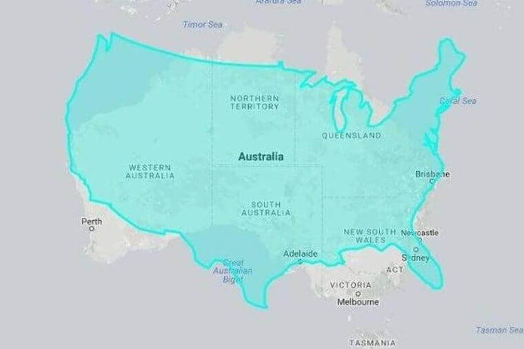
In terms of size, Australia is 27 percent smaller than the United States, which is illustrated on this map. It may be a smaller country, but it also has a much smaller population to support. America needs all the space it has to support its growing population.
The Population Of LA County
With such a huge population, some of the counties in the United States are stuffed to the brim with people. Los Angeles County, found in the state of California has a population size that is bigger than the state population for the majority of America.
Stuffed within that tiny county are over 10 million people who call the place home! The county population is similar to the state populations in Georgia, Pennsylvania, and New York, just to name a few. Finding decent housing here must cost some serious dollars!
Cuba Compared To Hudson Bay
The island nation of Cuba has been a popular holiday destination for decades, and with its recent opening to the United States, Americans have begun to flock there. Cuba might look like it is fairly big on a world map, but when compared to Hudson Bay in North America, it looks smaller than a lot of the provinces surrounding the Bay.
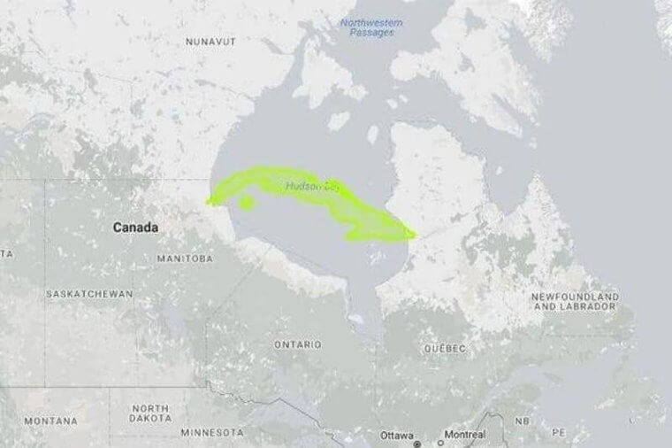
Cuba is about one-twelfth the size of Hudson Bay, and when it’s placed smack dab in the center of it, it looks like it is sitting underneath the water. If Cuba starts sinking like the Maldives, it will become nothing more than a sand bar, but that’s not going to happen anytime soon. Book a vacation, and go lounge on its sunny shores.
Sizing And Population Density
A lot of the states within America are sparsely populated, especially those in middle America and in the Pacific Northwest. It’s not because people don’t want to live here, but for the Pacific area it is quite expensive, and in the Midwest, there are not as many job opportunities as in the cities.
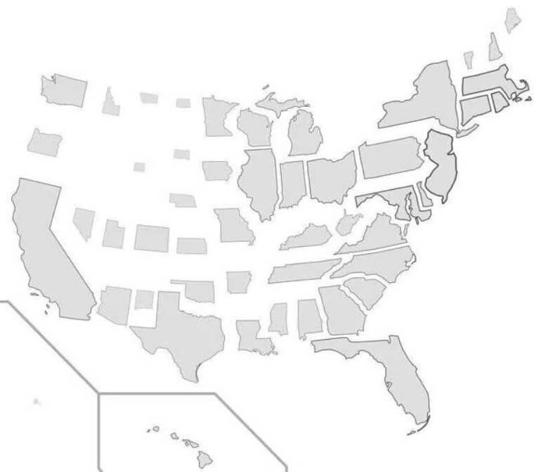
Based on population density, this is how the states would look if they were turned into a map. As you can see, most of the population continues to be along the coasts and along the border with Canada. If you feel like moving and getting away from densely populated centers, then this map will help you.
Land Mass Of China And America
The most populous country in the world is China. The country in East Asia has held this title for many years, and luckily, it does have a large landmass to support the ever-growing population. However, the United States does give it a run for its money, in terms of land size.
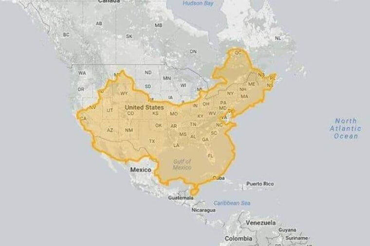
When superimposed over each other, the United States just squeaks by and is a tad bigger in terms of land size. The two populous countries are almost identical in size, but America is 9,833,517 sg km and China is 9,596,961 sq km. If this was a competition, the United States would be the land size winner.
Favorite Coffee Chains
The United States is full of little bistros and cafes with their own carefully made brews. Some serve up delicious cold brews, while others focus on fancy coffees full of frothy designs on top that baristas dream up. When it comes to coffee chains though, there are three brands that reign supreme.
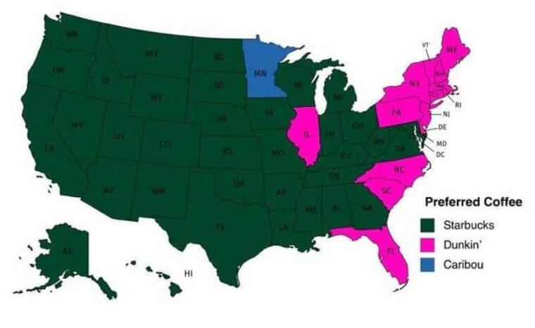
For most of the states, Starbucks, which originated in Seattle, Washington is the go-to for most coffee lovers. On the Eastern seaboard, Dunkin’ Donuts is a contender for second place, with most of the east coast states preferring it. Caribou Coffee in Minnesota gets an honorable mention, as it is the only state that likes that chain.
India And The United States
Behind China, India is the country with the second-largest population. Its borders contain roughly 1 billion people, dispersed all throughout the country. When looking at a world map, India does not appear to be that big, but in reality, it is the seventh biggest country in the world.
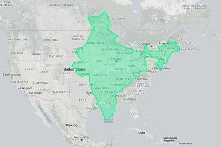
With India superimposed over the United States, we are once more reminded of the size of America. India may be large and have a massive population, but it is still dwarfed by the North American giant. It is about half the size of America, which is still very big. World maps need to start doing it a bit more justice and showing its scale.
Countries With Lower Populations
While we have seen a lot of maps featuring the United States and its population size and density, there are still dozens of other countries that deserve some attention. This map shows all of the countries that have populations less than 100 million, which is quite a few.
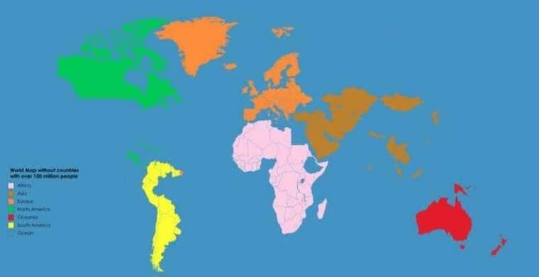
One of the reasons countries like New Zealand, Canada, and Australia have significantly smaller populations and large land sizes are due to the climate itself. The harsh arctic climate in Northern Canada makes it very difficult for people to live there, and the arid desert climate in parts of Australia is the same. That means that countries with pleasant climates, tend to have bigger populations.
The Mediterranean Sea of America
There’s a common stereotype that many Americans have never even left the country to travel the world. Everything they see is from the perspective of the US, including the oceans surrounding the country and the Great Lakes in the middle. So many Americans have trouble conceptualizing the size of other places around the globe. The Mediterranean Sea, for instance: how big is it really? It may not be so easy to grasp its true size from looking at a regular map.
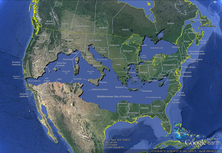
With some complicated graphic manipulation and excellent Photoshop skills, this internet user has come up with a map to show the true scale of the Mediterranean Sea and its surrounding countries — Overlaid perfectly on the contiguous United States. Goodbye Midwest, hello Italian Riviera!
The Nearest Country To Everywhere In The US
Most of the time when we think about countries around the United States, the only two that come to mind are Canada to the north and Mexico to the south. But there are entire regions of the United States that are closer to entirely different countries, especially the often-overlooked states of Alaska and Hawaii. Needless to say, most of the US is indeed closest to Canada or Mexico. But what are the other nearby countries?
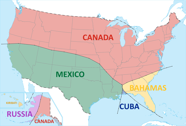
In fact, about half of Alaska is closer to Russia than to anywhere else — even Canada. And most of the Southeast US, including Florida, is closer to the Bahamas than to Mexico. And how many of us knew that Hawaii was so close to Kiribati?
China Meet Russia
When you stare at a world map, one country immediately stands out for its size – Russia. By land size, Russia is the largest country in the world. However, like other countries on here, it has areas that are sparsely populated due to the harsh winter climate. To put it into perspective just look at how big Russia is after taking a look at China superimposed over it.
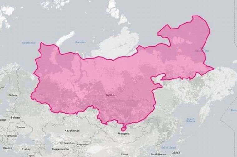
China is not as small as maps make it look in comparison to Russia, although it is still substantially smaller. if you’re measuring by land size itself, Russia is a whopping 44 percent larger than China.
All Of Antarctica
Most maps show Antarctica as this long-snaking continent that lives at the bottom of the world. Unless you are looking at a globe, it is hard to conceptualize that Antarctica is actually a rounder continent instead of one that is long and skinny.
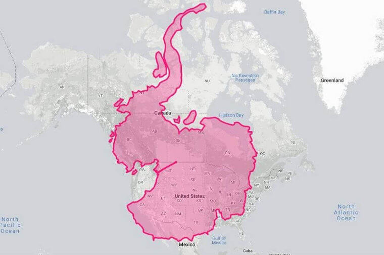
Antarctica does not have a permanent population the way the other continents do, as it is made up of scientists, researchers, and support staff who work on a rotational basis. To understand just how big Antarctica is, you need to compare it to all of North America. It might not be as big, but if it was a country, Canada would be 40 percent smaller than it.
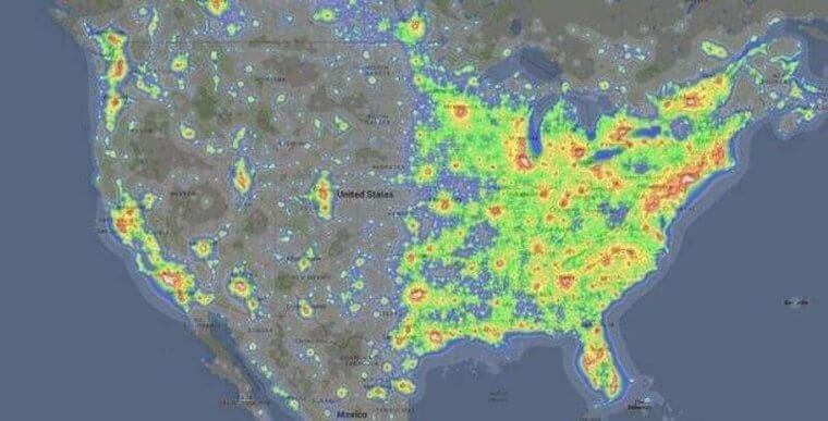
Noise Pollution In America
Anybody who has spent time in a city knows that it is all about the hustle and bustle. Cars honk, nightclubs blare music, and sirens go off. This cacophony of sound all contributes to what is known as noise pollution.
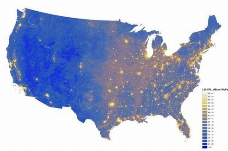
This map shows lit-up areas, which are all focused in major cities like Los Angeles, New York, and Miami. Each of these cities has massive populations, which in turn leads to more noise. If you enjoy the quiet, then you will need to head to the center of the country. We hear Maine is a good choice.
Population Spikes
In order for a country to get bigger, it needs to have a steadily growing population. For example, Japan has an aging population and little immigration which has led to a decline in population size. This map shows where all of the spikes or population growth are happening in the United States.
A lot of these spikes are concentrated in the major cities, which regularly experience an influx of immigrants. Along the Canadian border, there aren’t really any spikes, and that might be due to the fact that there aren’t major cities in middle America along the border.
Montana And Mongolia
Montana and Mongolia share a few similarities. Both are sparsely populated, have huge swathes of land for livestock to roam on, and a thriving agricultural sector. When it comes to land size that is where the two begin to differ, amongst many other aspects.
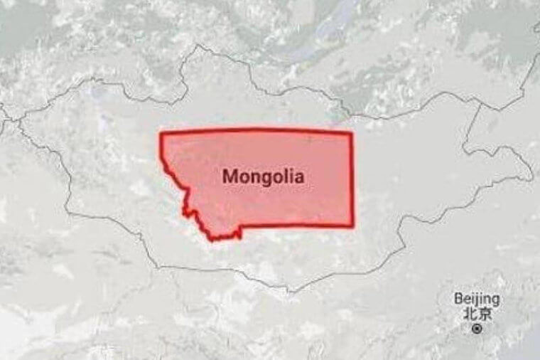
In terms of land size, Montana is 4.1 times smaller. What is odd, is that mapmakers like to make Mongolia look like a massive country in Asia, when that is not actually the case.
Road Tripping Through Springfield
For some odd reason, Springfield is one of the most popular names for towns in the United States. In 25 states alone, there are a grand total of 33 towns which all have the name of Springfield. Due to this, road trippers have begun to chart the best route that allows them to visit all 33.
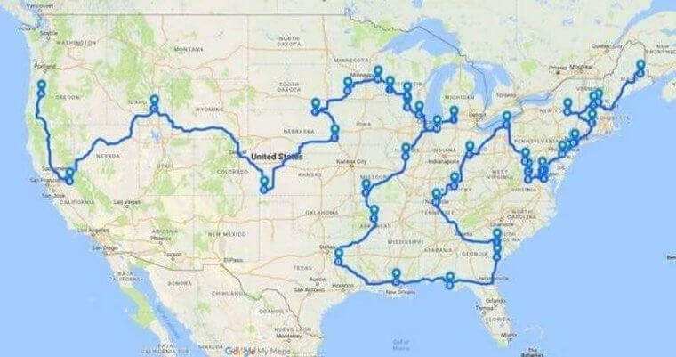
If you have been looking to embark on an adventure, then heading to one of the many Springfields would make for an excellent road trip. This map shows the route which allows you to visit the majority of the Springfields. There are a few townships that also share the name.
Poland Versus Texas
The Eastern European country of Poland is known for its scrumptious perogies and beautiful architecture that makes you feel as if you have gone back in time. In yet another edition of Texas versus a country, Poland does not exactly come out on top.
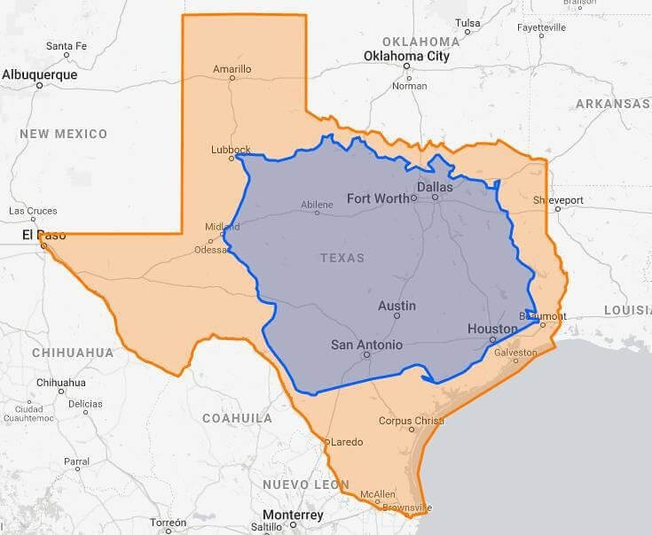
Poland itself is large, but Texas is larger. In this instance, everything is bigger in Texas. Although, we are not sure if the food in Texas is better. Poland might win in a cuisine competition.
Countries Inside The United States
It can be a lot of fun to make your own maps, especially when it comes to seeing just how many countries can fit inside the continental United States. One Redditor decided to see how many random foreign countries from Europe and Asia could fill the continental US’ borders.
As you can see, a ton of countries can fit inside America. Even though America is big, and densely populated in some states, there is still a lot of it that is rather unpopulated.
North America At Scale
Lots of people go to school to learn about geography or the art of mapmaking through applications like Geographic Information Mapping System. For anyone who has put the time in to learn about size comparisons, they know that maps are not always scaled correctly.
The United States tends to be given a spot of prominence and enlarged in maps when really, South America and Africa are much larger. When looking at maps, always keep scale in the back of your mind.
Cities With 100,000+ People
Cities like New York City, Miami, and Seoul in South Korea have populations that number in the millions. Many other cities don’t come anywhere close to sharing a population that size. To put it into perspective, take a look at this map, which features black dots for cities with 100,000+ people in them.
You will notice, that there are not that many cities that actually have large populations. In some cases, the majority of the populations live outside of urban centers, which might account for the smaller populations.
The Majority Of The Globe’s Population
By now, we know which countries are the most populous in the world: China and India. They also happen to be on the same continent, which means much of the world’s population is located within the Asia-Pacific region.
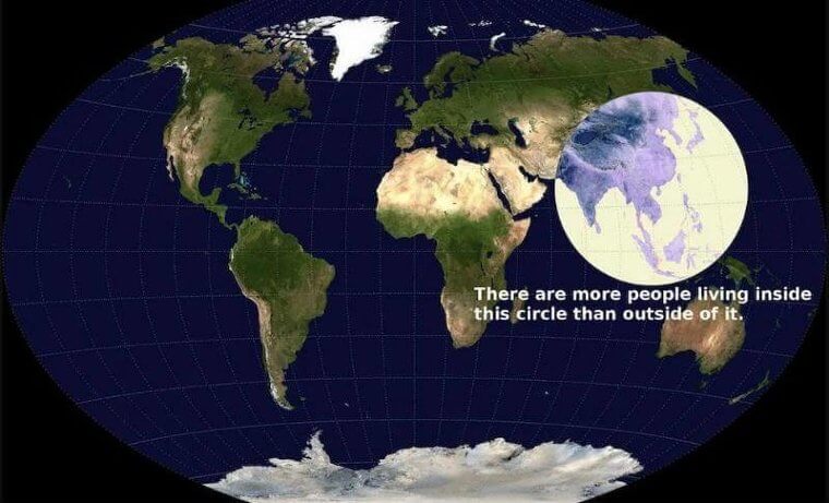
The highlighted circle on this map is where the majority of the world’s population resides and it is all in Asia. If you thought the United States was densely populated, then think again. It only accounts for 5 percent of the global population.
The Number One Sport
Over the centuries different sports have risen in popularity. In ancient Greek times, sports like javelin throwing and running were the norm. Now in the 21st century, there is one sport that continues to dominate around the globe.
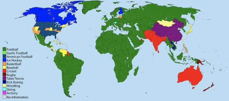
If you guessed soccer or football as it is known in many other countries, then you are correct! Soccer is played around the globe, and hooligans continue to attend games and watch them on television whenever they are broadcast.
Wild Fires Around The Globe
Climate change is real, and many countries around the world are experiencing the effects of it. One of the effects is a rise in wildfires, which have begun to sweep through countries like Australia, the United States, and Canada.
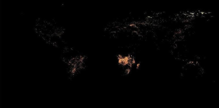
In an effort to raise awareness, the Earth Observatory Team run by NASA released a map of where all the active fires were burning. This image from 2020 highlights the importance of stemming climate change, and actively doing what we can to slow it down.
What Side Of The Road To Drive On
Anyone who has traveled outside of North America to the United Kingdom or a Commonwealth country is well acquainted with driving on the left side of the road. Left-side driving stems from the past when automobiles were first invented.
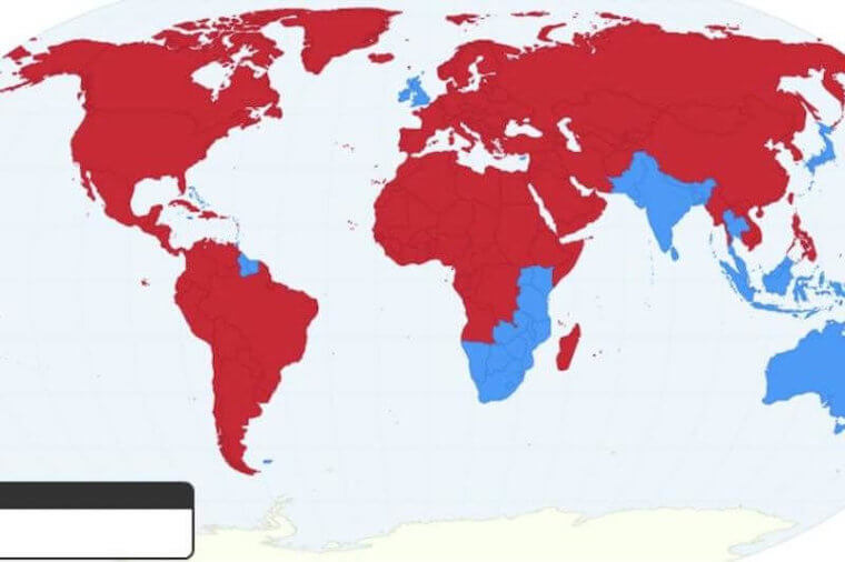
In the United Kingdom, they have continued to drive on the left side, and their former colonies that are part of the Commonwealth have continued with this as well. When in doubt about which side to drive on, always look at traffic, and refer to this handy map.
Populations Across The Map
While landmass helps to determine the population size that it can support, there are a number of other factors that come into play. For example, populations tend to grow in areas that have a climate that isn’t harsh, access to resources like fresh water and arable land, and ports that can be used for trade.
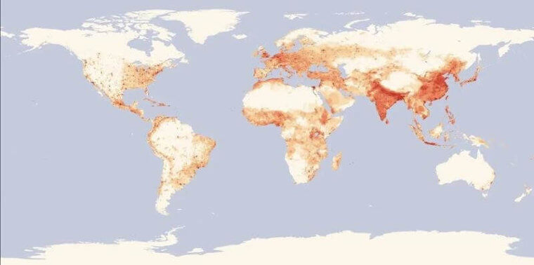
Looking at this map, which shows how the world’s population is dispersed, you can see that these factors are important. Much of the population is concentrated along the coasts of continents and sparsely populated in regions that experience arctic temperatures. Nobody enjoys being cold!
A World Map To Scale
With so many maps not drawn to scale, it is time to look at one that accurately represents what countries’ landmass actually looks like. The Hobo-Dyer Equal Area Projection team produced this map which shows just how big continents and countries are in relation to one another.
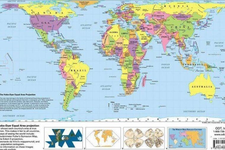
Africa is much bigger than it is normally shown, which is important as it is becoming an economic powerhouse, and is undergoing massive population growth. The United States is also much smaller than it normally appears, which is important because while it is economically important, it is not the largest by landmass.
Just How Big Is Australia?
The land down under, or Australia has a total size of 7.7 million square kilometers, which makes it one of the bigger countries and continents on the map. It can be hard to put into perspective just how big that is, without comparing it to other countries.
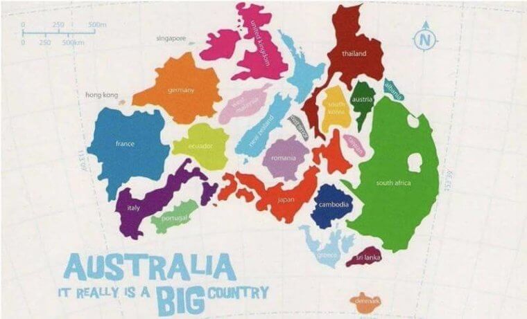
This map shows how countries like Thailand, South Africa, and many more comfortably fit within its borders. There is even room to spare for a few smaller countries, like Luxembourg, if we wanted to add a few more. If you want to live in a country with a hot climate, a ton of wildlife, and very few people, then Australia is the place to be.
Understanding Mercator’s Projection
Mercator’s Projection is by no means a new way of designing maps. In 1569, a man by the name of Gerardus Mercator introduced his mode of mapping. It is the process of using meridians, lines of latitude and longitude, and following the equator to create a cylindrical projection.
This method of mapping continues to be used, especially in navigation charts. The problem with this method of mapping is that it is not always accurate. As the lines used do not always display exactly where continents should be situated on a flat map.
How Big Is Japan?
East Asia is primarily composed of South Korea, China, and Japan. Japan tends to be shown as a small island nation off the east coast of Asia, but that is not exactly accurate. Mercator’s Projection is responsible for making Japan smaller than it appears on maps, but this should put it into perspective.
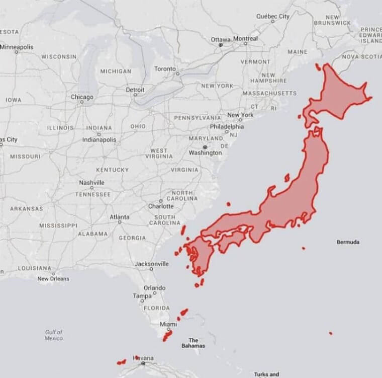
Japan, when compared to the east coast of the United States is actually quite large. On top of that, it contains a population of over 126 million people. That is about a third of the United State’s population, which is impressive considering how much smaller Japan is in terms of landmass.
Where Canadians Live
There are a lot of stereotypes surrounding Canada. Canadians do not live in igloos, ride moose to school, and drizzle maple syrup on top of everything. That being said, most Canadians do tend to live close to the border with the United States or along the coasts.
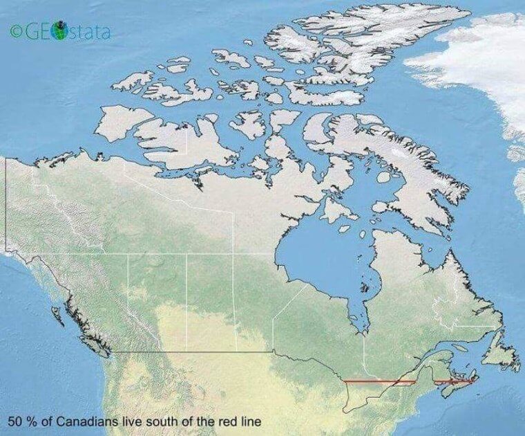
This red line showcases where most of the Canadian population lives. It is concentrated on the east coast in the provinces of Ontario and Quebec. Part of this is due to the fact that Toronto and Montreal are two of the biggest cities in Canada, and are in these provinces. With 20 million people living in that area, the rest of Canada is largely untouched.
Migratory Routes In North America
While humans may choose not to live in Northern Canada, many animals continue to roam around the landscape. In the Northwest Territories, Nunavut, and the Yukon, herds of caribou follow strict migratory paths each year. That is true for many other animals from birds like Canadian geese to the great big water mammals such as beluga whales.
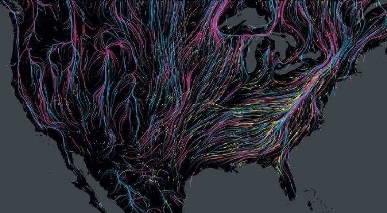
Every animal that migrates follows a route, typically from north to south, so that it can enjoy warmer temperatures in the frigid winter months. This map primarily focused on mammals that migrate, but insects like monarch butterflies are also known to follow specific paths.
Countries That Share Borders
By examining a map, it is obvious what countries share borders. The Topologist’s Map of the World shares a slightly different view though. Instead of staring at a traditional map of the world, the Topologist’s Map places countries that have borders that touch by continent.
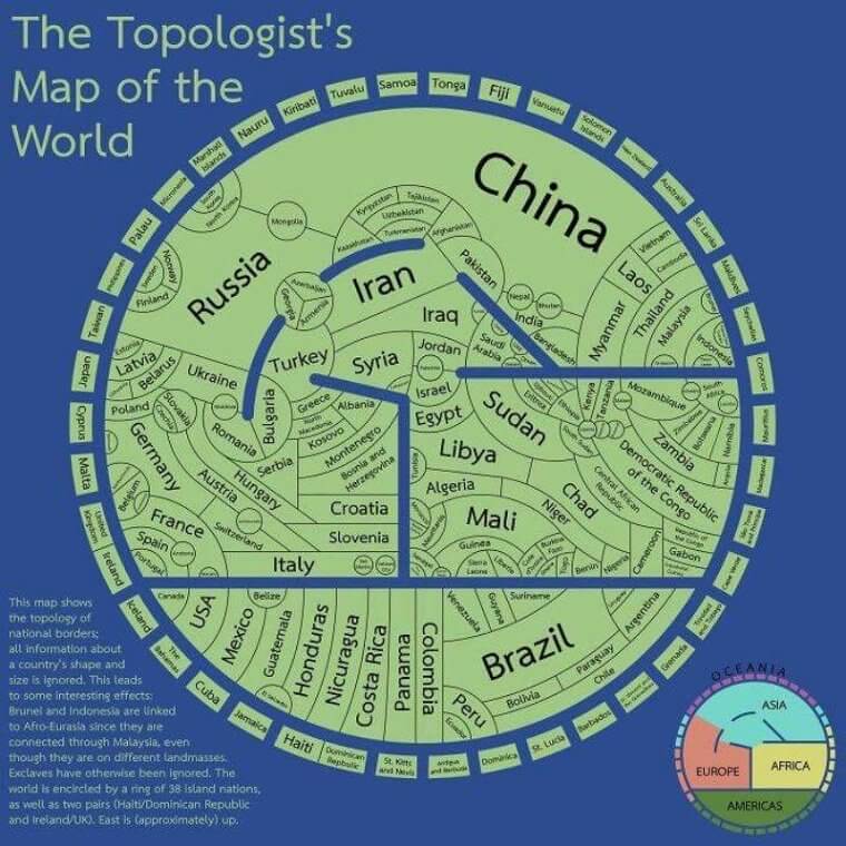
Each continent is separated by a blue line, and the small curved rectangles that circle the continents are islands that don’t border them directly but are in the same vicinity. Conceptually, this map is very easy to understand, although it does not accurately show landmass to scale which is a limitation. This is just another way of looking at the world
The Rivers Of America
Countries which are rich in water are able to irrigate land used for farming, provide clean water to their populations, and even export water as a commodity. America is fortunate to be home to a whopping 250,000 rivers, which traverse over 3.5 million miles of land.
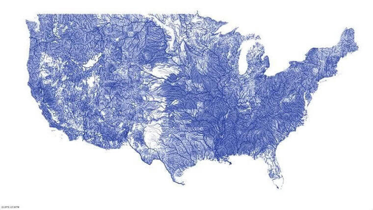
Everywhere you turn, it feels like there is a river or a stream trickling by. With so many rivers in the continental United States, it should come as no surprise that there is one over 2,540 miles long. The Missouri River wins the title for the river spanning the greatest distance in America.
The Mighty Mississippi River
The Missouri River might have won the title for the longest river, but it is not the river that contains the largest volume of water. That title goes to the Mississippi River. The red section on this map shows all of the rivers that feed into the Mississippi.
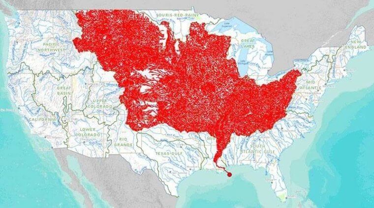
It is estimated that around 7,000 rivers that traverse the United States eventually lead into the Mississippi River and that is what turns it into the raging river we know and love. You will see that the Mississippi River eventually flows into the ocean, and straight into the Gulf of Mexico.
Reaching 1 Billion
With over 7 billion people on this planet, it is hard to conceptualize that most of that population is situated in Asia, Africa, and South America. To detail this, take a look at this color-coded map. Each color shows how the world’s populations combine to reach 1 billion people in specific regions. For example, it would take North America, South America, and Australia to reach 1 billion people.
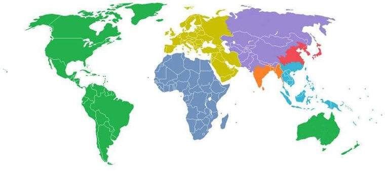
India and China have one billion people apiece, with Africa, Europe combined with the Middle East, parts of Asia, and Oceania making up the rest. That is a lot of people for Mother Earth to support.
To The Moon And Back
It’s finally time to go off-planet and take a look at the moon. Space exploration is still in its infancy, but slowly but surely we are getting closer to exploring other planets and what the universe has to offer. The moon is something every person on this planet sees, but how big is it really?
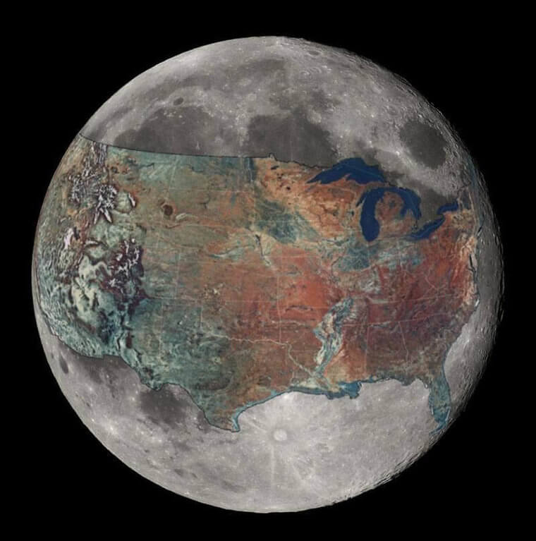
With the United States of America superimposed over the surface of the moon, you can see that it takes up almost the entire side of it. If Asia had been superimposed, it would have covered almost the entire landmass of the moon. The moon is pretty small when you think about it in those terms.